Saved for a Rainy Day
I've been trying to find a way to map homicides in Milwaukee, just to see if there actually is a pattern. Big thanks to Belle for tipping me off to this! I guess liberals aren't totally useless, after all.
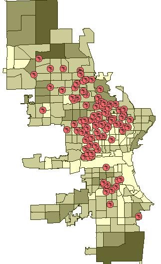
Based on this map, where in Milwaukee would you prefer to live? There certainly seems to be a large cluster of negative mojo north of the valley, doesn't there?
But, wait! This wonderful site can map other crimes. What does the city look like if you include them all? Answer: it looks like hell. Those pretty purple blotches are aggravated assaults, by the way. Apparently, the safest place in town is the airport. I just wish this map included the suburbs, for comparison. Arson, especially, seems to be more common in the outlying areas.
Oh, and in the interest of fairness there are some disclaimers with this mapping service:
Based on this map, where in Milwaukee would you prefer to live?
 There certainly seems to be a large cluster of negative mojo north of the valley, doesn't there?
But, wait! This wonderful site can map other crimes. What does the city look like if you include them all?
 Answer: it looks like hell. Those pretty purple blotches are aggravated assaults, by the way. Apparently, the safest place in town is the airport. I just wish this map included the suburbs, for comparison. Arson, especially, seems to be more common in the outlying areas.
 Oh, and in the interest of fairness there are some disclaimers with this mapping service:
- the information represents only police services where a report was made and does not include other calls for police service
- the information does not reflect or certify "safe" or "unsafe" areas
- the information will sometimes reflect where the crime was reported versus where the crime occurred
posted by Aaron @ 10:25 PM
![]()


<< Home